The ApartmentYour place on the Corniche d'Or
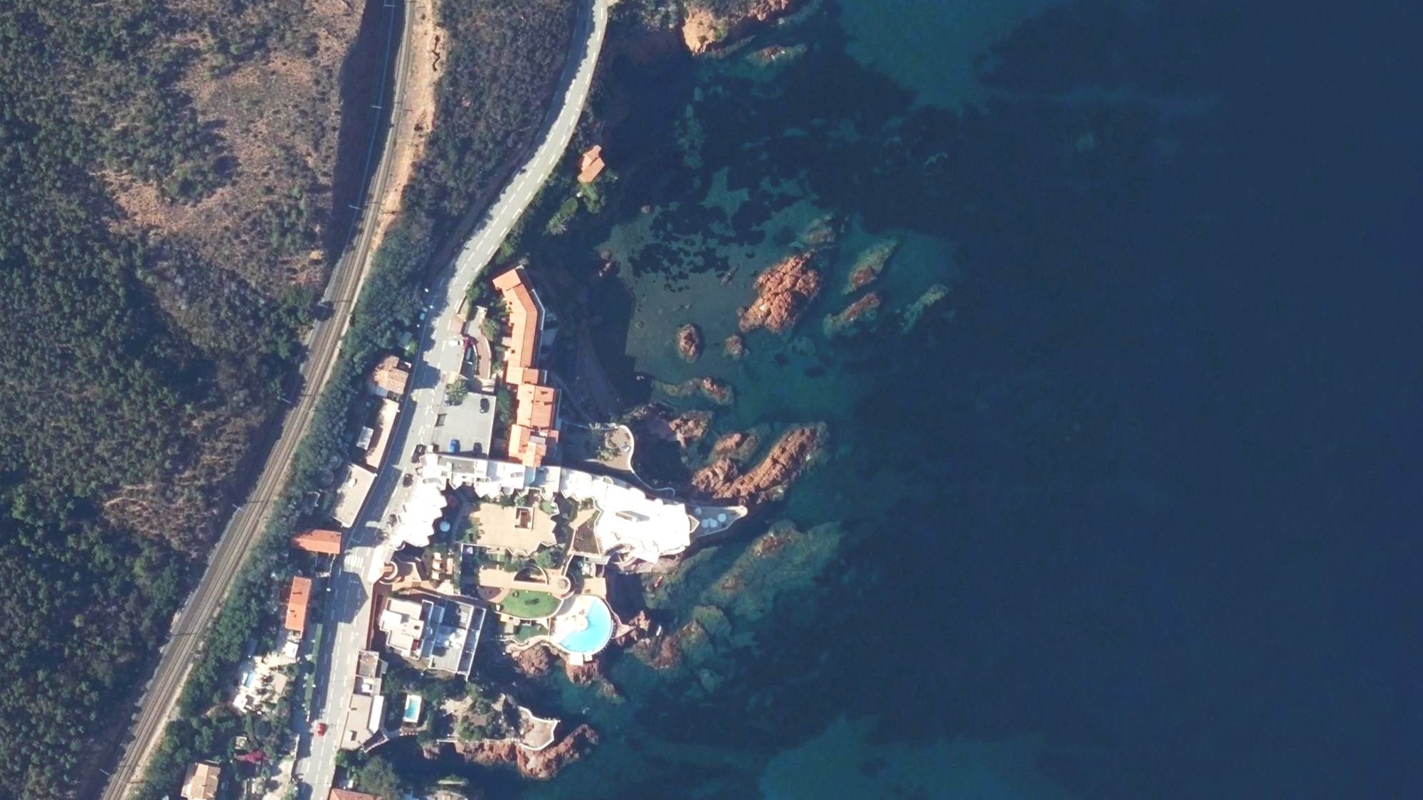
Le Cyclos sits right on the water at Le Trayas, the wildest stretch of coast between Saint-Raphaël and Cannes. Here the Estérel massif tumbles into the Mediterranean in fingers of red volcanic rock, sheltering a quiet cove and little beach right below the residence — you can see both in the aerial view above.
Apartment 12 is a one-bedroom apartment that sleeps four: a simple, comfortable base for all of it. Swim before breakfast, walk the corniche for lunch, and take the little coastal train to Cannes from the station up the hill.
Things to DoRed rocks, blue water
The Estérel is a protected massif of volcanic peaks and hidden coves — most of what's best here is outdoors and minutes from the door.
Climb the Pic du Cap Roux
The signature Estérel hike: a 453 m summit with a sweep of coast from Antibes to Saint-Tropez. Go early, while it's cool and the light is soft. The Pic de l'Ours (about 490 m) and the Belvédère du Trayas are fine alternatives. In summer, check the massif-access map before setting out.
View on map: Pic du Cap Roux (opens Google Maps)Swim the calanques
Start in the cove right below the residence, or walk 15 minutes south to red-pebble Maubois. A short drive further: the Calanque d'Anthéor beneath its elegant rail viaduct, and Saint-Barthélemy at the foot of Cap Roux.
View on map: Calanque d'Anthéor (opens Google Maps)Snorkel the Cap Roux reserve
The Cap Roux marine reserve runs from Le Trayas, right below the residence, south to the Pointe de l'Observatoire. Closed to fishing for over twenty years, it's alive with grouper, bream and octopus — snorkel straight from the cove. All fishing is banned year-round, including from the rocks, spearfishing and sea-urchin gathering. Dive boats from Agay and Saint-Raphaël head further out.
Kayak & paddle the coast
Rent kayaks and paddleboards on Agay bay and work along the coast into coves you can't reach on foot. Boat tours from Saint-Raphaël open up sea caves and the wilder calanques.
View on map: Agay bay (opens Google Maps)Ride the coastal train
Le Trayas has its own halt on one of France's prettiest lines. From the station: Théoule 5 min, Agay 9, Cannes 16, Saint-Raphaël 20, Fréjus 25, Antibes 27. Trains run roughly hourly, with a gap around midday, and the last train back from Cannes leaves around 9 pm on weekdays (earlier in winter, later on Fridays and Saturdays).
Check train times on SNCF Connect (opens in a new tab)Traverse the Estérel
Behind the coast, over 100 km of waymarked forest tracks climb through cork oak and red porphyry — superb for mountain biking and trail running, and the Corniche d'Or itself is a classic road ride. In summer, access depends on the day's fire risk.
Massif access map (Var prefecture, opens in a new tab)Within Walking DistanceNo car, no problem
The best of Le Trayas is on foot — a swim, a snack and a sea view, no car keys needed.
Your cove & beach
Steps from your door: the sheltered cove and little beach right below the residence, the one in the aerial view above. First swim before breakfast, last swim before dinner. It's part of the marine reserve, so look, don't fish.
Snack La Cabane Chez Monique
A much-loved snack shack on the corniche just south of the village — burgers, paninis, salads and fresh calamari on a terrace over the sea. Generous, friendly and unfussy; it's a lunch spot and closes by early evening.
View on map: Snack La Cabane Chez Monique (opens Google Maps)Maubois cove
A short walk south along the corniche, just past Chez Monique, then steep, narrow steps down to a 150-meter red-pebble cove framed by Estérel rock. Clear, calm water made for snorkeling. No lifeguard.
View on map: Maubois cove (opens Google Maps)Le Trayas station
Up through the village lanes to the little halt on the coastal line — Cannes in 16 minutes, Saint-Raphaël in 20. Trains run roughly hourly, so check the times before you set off.
View on map: Le Trayas station (opens Google Maps)Pointe de l'Observatoire
Half an hour south along the corniche to a rocky promontory with some of the reddest rock and clearest water on the coast, at the southern edge of the marine reserve. Bring a mask and snorkel.
View on map: Pointe de l'Observatoire (opens Google Maps)Estérel trailheads
Footpaths climb from the village into the massif — steep lanes and forest tracks leading to viewpoints high over the bay. In summer, check the daily massif-access map first (see Good to Know).
Walking the corniche: parts of the coast road (D559) have no sidewalk. Walk facing oncoming traffic, in single file, and carry a light after dark.
Places to EatTables by the water
From feet-in-the-sand lunches to seafood over the harbor. Closest of all is Snack La Cabane Chez Monique, a five-minute walk away.
La Maréa
Seafood overlooking the little port of La Figueirette at Miramar, with big windows on the sea. Open much of the year on selected days — check lamarea.fr before you go.
View on map: La Maréa (opens Google Maps)L'Or Bleu
The special-occasion table: modern Mediterranean cooking at the Tiara Miramar Beach Resort, set in its own cliff-backed cove. Dinner Tuesday to Saturday; the resort closes in January.
View on map: L'Or Bleu at Tiara Miramar Beach (opens Google Maps)Les Flots Bleus
A seaside hotel-restaurant on the Saint-Barthélemy road, beside the Anthéor viaduct, with tables right over the water. Fish and Mediterranean classics, generous and relaxed.
View on map: Les Flots Bleus (opens Google Maps)Marco Polo
Feet-in-the-sand beach dining on Théoule's shore — grilled fish, pasta and rosé with the Estérel glowing across the bay. Book ahead in summer.
View on map: Marco Polo (opens Google Maps)La Belle Vie Café
A shaded terrace across the sweep of Agay bay. French and European plates with real vegetarian options — an easy, friendly lunch after the beach.
View on map: La Belle Vie Café (opens Google Maps)Amici
Traditional Italian on the marina at Port Santa Lucia — a good excuse to stroll past the yachts before dinner.
View on map: Amici (opens Google Maps)Many beach restaurants close from autumn to spring, and some open only on certain days — check before you go, and book ahead in summer.
ShoppingMarkets & provisions
Where to stock the kitchen, from the village shop to the weekly market, and where to find something to bring home.
Supérette La Fourmi
The village's own little grocery at 1205 Route des Calanques: bread, newspapers, fresh vegetables and the basics. Open mid-March to mid-December; closed at midday.
View on map: Supérette La Fourmi (opens Google Maps)Everyday essentials
Agay's beach boulevard has the nearest bigger grocers — Utile (661 bd de la Plage), Vival (105 bd de la Plage) and Spar Agay la Plage — plus Côté Provence for Provençal gifts.
View on map: Agay grocers (opens Google Maps)Agay market
Every Wednesday morning (8:30 am–1 pm, year-round) the village market fills with local produce, flowers, cheese and crafts — the easiest way to shop like you live here.
The big shop
For a proper weekly shop: the E.Leclerc hypermarket in Saint-Raphaël or Auchan at Mandelieu-la-Napoule, both about 25 minutes away, or Super U on boulevard Jean Moulin in Saint-Raphaël, about 30. For top-ups, stick to the village shop and Agay.
View on map: E.Leclerc Saint-Raphaël (opens Google Maps)Saint-Raphaël markets
Open-air morning markets in the town center, plus the fish market on the Vieux-Port — Provençal fruit and vegetables, olives, spices, flowers and fish straight off the boats.
Cannes shopping
Rue d'Antibes for boutiques and big names, the covered Marché Forville for one of the Riviera's best food markets, and La Croisette for window-shopping the couture houses.
View on map: Marché Forville (opens Google Maps)Day TripsDays out, near and far
Le Trayas sits midway between Saint-Raphaël and Cannes — the whole Riviera, from Saint-Tropez to Monaco, is within day-trip reach.
Théoule-sur-Mer
The nearest village on the Cannes side: a small harbor, beaches, cafés and morning essentials, tucked under the red cliffs of the corniche.
View on map: Théoule-sur-Mer (opens Google Maps)Agay
A deep, sheltered bay with sandy family beaches, watersports, markets and most everyday shopping — the practical heart of this stretch of coast.
View on map: Agay (opens Google Maps)Cap Dramont & the Île d'Or
A gorgeous headland walk around the semaphore, looking onto the tiny gold-stone tower island said to have inspired Hergé's The Black Island. Sunset here is unmissable.
View on map: Cap Dramont (opens Google Maps)Saint-Raphaël
Your nearest town: a palm-lined seafront, busy marina, morning markets and the archaeology museum — with all services and the mainline station.
View on map: Saint-Raphaël (opens Google Maps)Fréjus
One of Provence's oldest Roman towns — amphitheater, aqueduct and an extraordinary medieval cathedral cloister — right next door to Saint-Raphaël.
View on map: Fréjus (opens Google Maps)Cannes
La Croisette and its grand hotels, old Le Suquet on the hill, the Palais des Festivals and the old port where the island ferries leave — glamour and people-watching half an hour away.
View on map: Cannes (opens Google Maps)The Lérins Islands
A 15-minute ferry from Cannes' old port to Île Sainte-Marguerite for pine-shaded paths and quiet rocky swimming, or on to Saint-Honorat, where monks still tend the vineyards around Lérins Abbey.
View on map: Île Sainte-Marguerite (opens Google Maps)Antibes
Ramparts over the sea, the Picasso Museum in Château Grimaldi, the Provençal market and Europe's biggest yacht harbor, with Juan-les-Pins' beaches next door.
View on map: Antibes (opens Google Maps)Nice
The capital of the Riviera: the Promenade des Anglais, tangled old-town lanes, the Cours Saleya flower market and Castle Hill views over the Baie des Anges.
View on map: Nice (opens Google Maps)Èze
A medieval eagle's-nest village suspended between sky and sea — climb to the exotic garden at the summit, then visit the Fragonard and Galimard perfume workshops below.
View on map: Èze (opens Google Maps)Monaco
The principality in a day: the Prince's Palace and old town on the Rock, the Oceanographic Museum, the harbor of superyachts and the belle-époque Casino de Monte-Carlo.
View on map: Monaco (opens Google Maps)Saint-Tropez
The legendary fishing-village-turned-jet-set harbor: café life on the old port, the citadel views, and Pampelonne's famous sands. Go early — summer traffic can add an hour — or better, go by boat.
View on map: Saint-Tropez (opens Google Maps)EntertainmentFun for everyone
Beyond beaches and hikes: waterparks and funfairs for the kids, casinos and nightlife for the grown-ups.
Aqualand Fréjus
The biggest waterpark on the French Riviera — slides and wave pools across thrill, family and little-kid zones. Open in the summer season; plan a full day.
View on map: Aqualand Fréjus (opens Google Maps)Luna Park
Fréjus' big summer funfair, right next to Aqualand — roller coasters and thrill rides for teens, a haunted train, and the secure Funny Land zone for children aged 1–10. Evenings from late May to late August.
View on map: Luna Park Fréjus (opens Google Maps)Fort Royal & the Iron Mask
On Île Sainte-Marguerite, kids can stand in the actual cell of the Man in the Iron Mask at Fort Royal's museum — a real-life mystery wrapped in a pirate-worthy island adventure.
View on map: Fort Royal (opens Google Maps)Fun on the water
Pedal boats and paddleboards for the little ones; license-free boat rentals, jet-ski and parasailing for bigger thrills — all from Agay bay and the Saint-Raphaël waterfront.
Casino & nightlife
Try your luck at the Casino Barrière on the Croisette, then cocktails at a beach club or a summer concert on the seafront. Plan to drive or take a taxi home, since the trains stop running early in the evening.
View on map: Casino Barrière Cannes (opens Google Maps)Night markets & fêtes
In July and August, Agay's night market takes over the beach boulevard on weekend evenings, and villages along the coast host fireworks, fêtes and open-air cinema.
Good to KnowBefore you go
The practical bits: getting here, staying safe in the hills and on the water, and where to find help.
Getting here
Nice Côte d'Azur airport is about an hour away by car. Mainline trains (TGV and Intercités) stop at Saint-Raphaël-Valescure, about 25 minutes away, and local TER trains stop at Le Trayas, a 15-minute walk up the hill.
Summer fire season
Each summer evening the Var and Alpes-Maritimes prefectures publish maps showing whether the Estérel is open the next day (Le Trayas sits right on their border). On red days the massif is closed to walkers and cyclists. Go early, carry water, and never smoke or light a fire.
Var access map (Var prefecture, opens in a new tab) Alpes-Maritimes map (Alpes-Maritimes prefecture, opens in a new tab)At sea
For sea rescue, call 196 (boaters: VHF channel 16). The small coves, Maubois included, have no lifeguards. In the Cap Roux marine reserve, from Le Trayas south to the Pointe de l'Observatoire, all fishing is banned.
Health
The nearest emergency department is the Fréjus–Saint-Raphaël hospital, 240 avenue de Saint-Lambert, Fréjus, about 35 minutes by car. For the on-duty pharmacy, search 3237.fr (postcode 83530) or dial 3237 from a French phone (paid call).
View on map: Fréjus–Saint-Raphaël hospital (opens Google Maps)Seasons
Summer is glorious but busy: start early and book restaurants ahead. From October many beach restaurants close, and the village shop closes from mid-December to mid-March.
The MapEverything, from here
The places in this guide, centered on Le Cyclos. Tap a marker for details and directions, and switch between “Zoom to Le Trayas” and “Show all” for the neighborhood or the whole coast.
- Le Cyclos
- Places to Eat
- Things to Do
- Day Trips
- Shopping
- Entertainment
Stays & ContactPlan a stay
Family, friends, or simply curious about Le Cyclos? Send us your dates and a note, and we'll get back to you.
Email: lecyclos@gmail.com · lecyclos.com